
Bongnaesan Mountain (395 m, Yeongdo-gu, Busan) is open all year round and the hiking trails are free, per the visitbusan.net city guide (checked October 4, 2026).
Busan’s English city guide currently runs a themed walking trip here — start at dusk, reach the summit in about an hour, then catch the sunset and the night view.
This post covers the bus route from Nampo Station, hours and fees, the four maintained courses side by side, parking, sunset timing and what to eat nearby.
Key facts — As of 2026-10-03
- Bongnaesan Mountain (395 m, Yeongdo-gu, Busan) is open all year round and the hiking trails are free, per the visitbusan.net city guide (checked 2026-10-04).
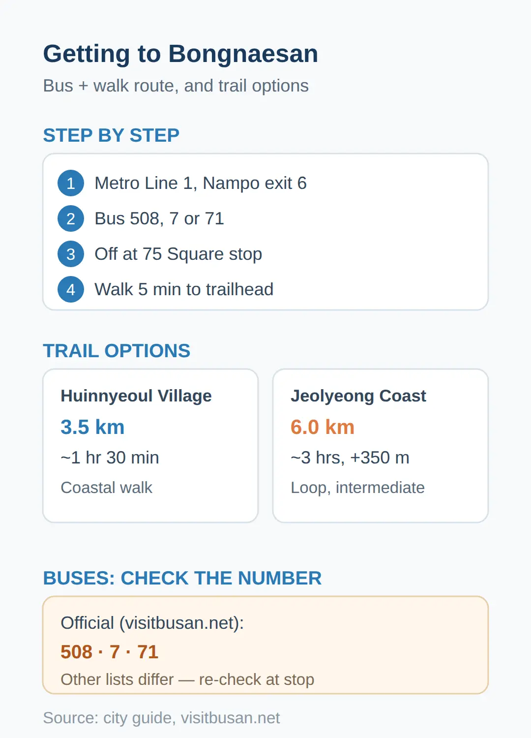
- From Nampo Station (Metro Line 1) exit 6, buses 508, 7 or 71 reach the 75 Square stop, from which the trailhead is a 5-minute walk, per the city guide.
- The Jeolyeong Coast Loop is 6.0 km and about 3 hours with +350 m of climbing, while the Huinnyeoul Village Course is 3.5 km and about 1 hour 30 minutes — roughly half the time.
How To Get To Bongnaesan Mountain Busan From Nampo Station
| Huinnyeoul Village Course | 3.5 km · ~1 hr 30 min · shortest up-and-down |
|---|---|
| Sinseon-dong boardwalk | 2.7 km out-and-back · ~1 hr 5 min · +186 m · lampposts |
| Mokjangwon Course | ~1 km to the summit · ~1 hour · wide forest road |
| Jeolyeong Coast Loop | 6.0 km · ~3 hrs · +350 m · intermediate |
From Nampo Station (Metro Line 1) exit 6, buses 508, 7 or 71 reach the 75 Square stop, from which the trailhead is a 5-minute walk, per the city guide.
The route is printed in the official visitbusan.net entry, so it is the one to trust first.
- Take Metro Line 1 to Nampo Station and go out exit 6.
- Board bus 508, 7 or 71 at the Yeongdodaegyo Bridge & Nampo Station stop.
- Get off at the 75 Square bus stop.
- Walk about 5 minutes to the trailhead.
The official Mokjangwon Course start is the Bongnaesan Dulle-gil Trail entrance at the back of the Mokjangwon building, 355 Jeoryeong-ro, Yeongdo-gu.
Other travel sources list different buses — bus 9 from exit 2 (every 20 minutes, about a 40-minute ride), buses 30 or 113 with a 15-minute walk, bus 71 from outside Jagalchi Market with a 6-minute walk, and one hiking site lists buses 6, 82 or 85.
Route numbers differ between sources, so re-check at the stop before boarding.
The first thing to check before anything else is the bus number and the drop-off stop, because that is what makes or breaks the trip.
Getting there — Bongnaesan Mountain
- Seoul → Busan by train: fastest 2h 18m, from ₩46,700, 109 trains a day, first 05:13 · last 22:40 · timetable
- Seoul → Busan by express bus: fastest 4h 00m, from ₩29,100, 35 buses a day, first 06:00 · last 24:00 · timetable
- Last leg: about 6.5 km from Busan Station — roughly 12 min by taxi or car without traffic; local buses also run (check the stop sign or a map app)
- Map: Naver Map · Kakao Map · Google Maps
Calculated by koreankorea.com from the national train and express-bus timetables, OpenStreetMap road distance. Plan your own route
Is Bongnaesan Open All Year And Free?
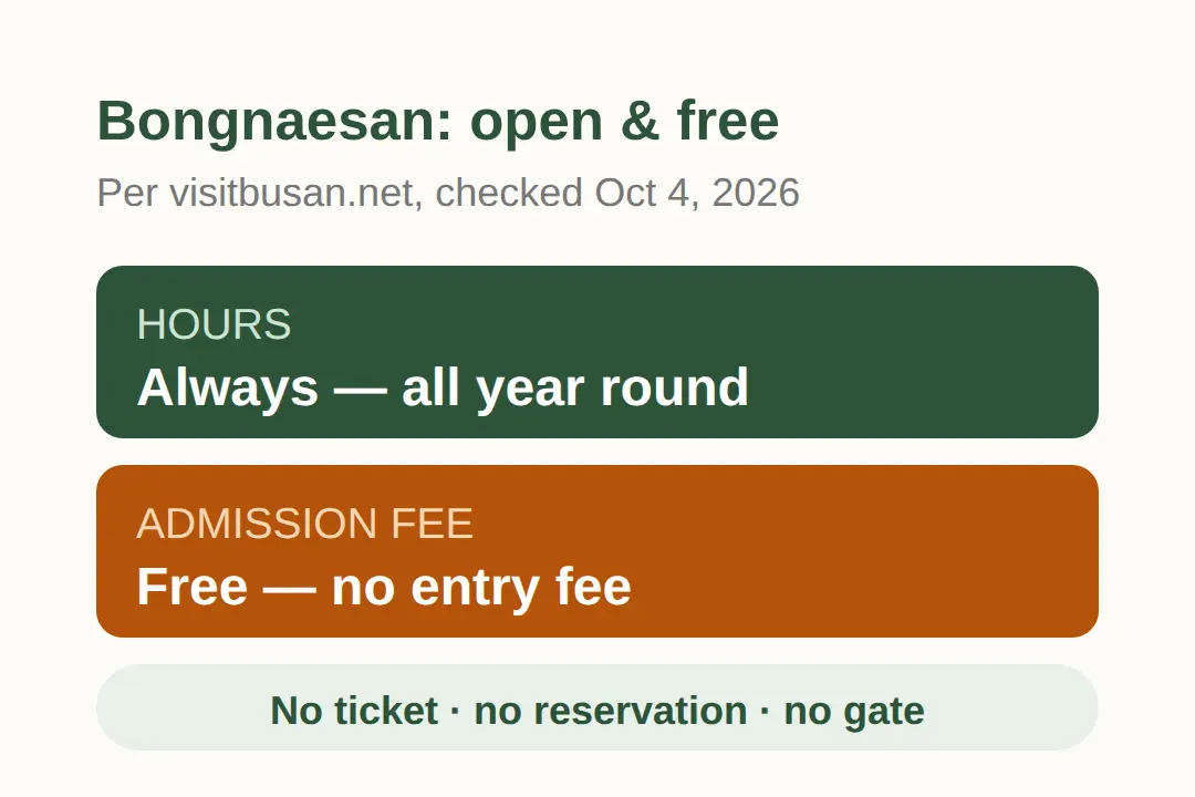
Bongnaesan Mountain is open all year round with no closed days, and the hiking trails are free, per the visitbusan.net city guide (checked October 4, 2026).
The guide lists hours as "Always" and fees as "Free", so there is no ticket, no reservation and no gate on the way up.
There is no fee to plan around, which makes it an easy add-on to a Busan day.
If a posted sign or a local notice says otherwise on the day, follow that — the city-guide page is the record to compare against.
Which Course Should You Pick? Four Routes Compared
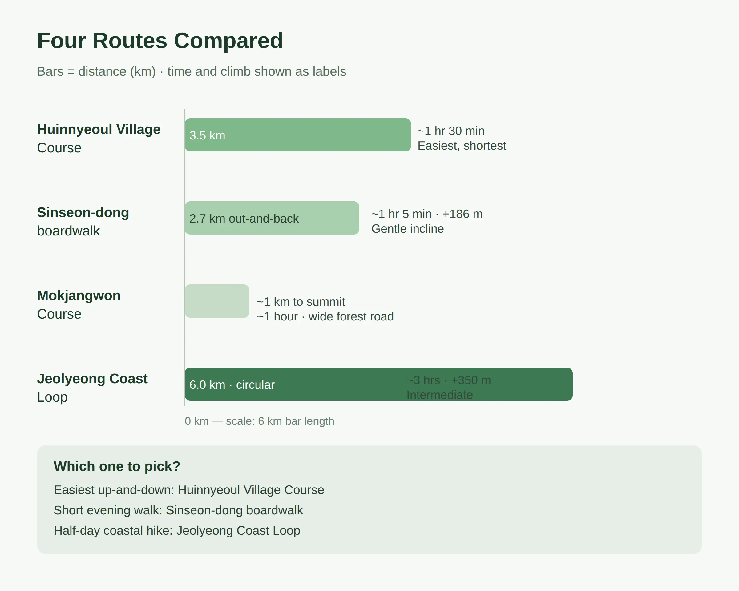
The Huinnyeoul Village Course is the shortest way up and down at 3.5 km and about 1 hour 30 minutes, while the Jeolyeong Coast Loop is 6.0 km and about 3 hours — roughly twice the time.
| Course | Distance | Time | Climb | Level |
|---|---|---|---|---|
| Huinnyeoul Village Course | 3.5 km | ~1 hr 30 min | — | Easiest, shortest |
| Sinseon-dong boardwalk | 2.7 km out-and-back | ~1 hr 5 min | +186 m | Gentle incline |
| Mokjangwon Course | ~1 km to summit | ~1 hour | — | Wide forest road |
| Jeolyeong Coast Loop | 6.0 km | ~3 hrs | +350 m | Intermediate |
The boardwalk from Sinseon-dong (via Sweet Potato Historical Park) is about 45% of the loop’s distance — 2.7 km against 6.0 km — and its +186 m of climbing is just over half the loop’s +350 m.
The loop runs Jungni Sports Park → summit (1.8 km) → Huinnyeoul Culture Village (1.7 km, steep stairs, ~40 min) → Jeolyeong Coastal Trail (1.5 km boardwalk) → back (1.0 km paved), and the main caution is the steep stair descent toward Huinnyeoul.
For the easiest up-and-down, take the Huinnyeoul Village Course; for a short evening walk, take the Sinseon-dong boardwalk; for a half-day coastal route, take the loop.
Parking, Summit Facilities And Water
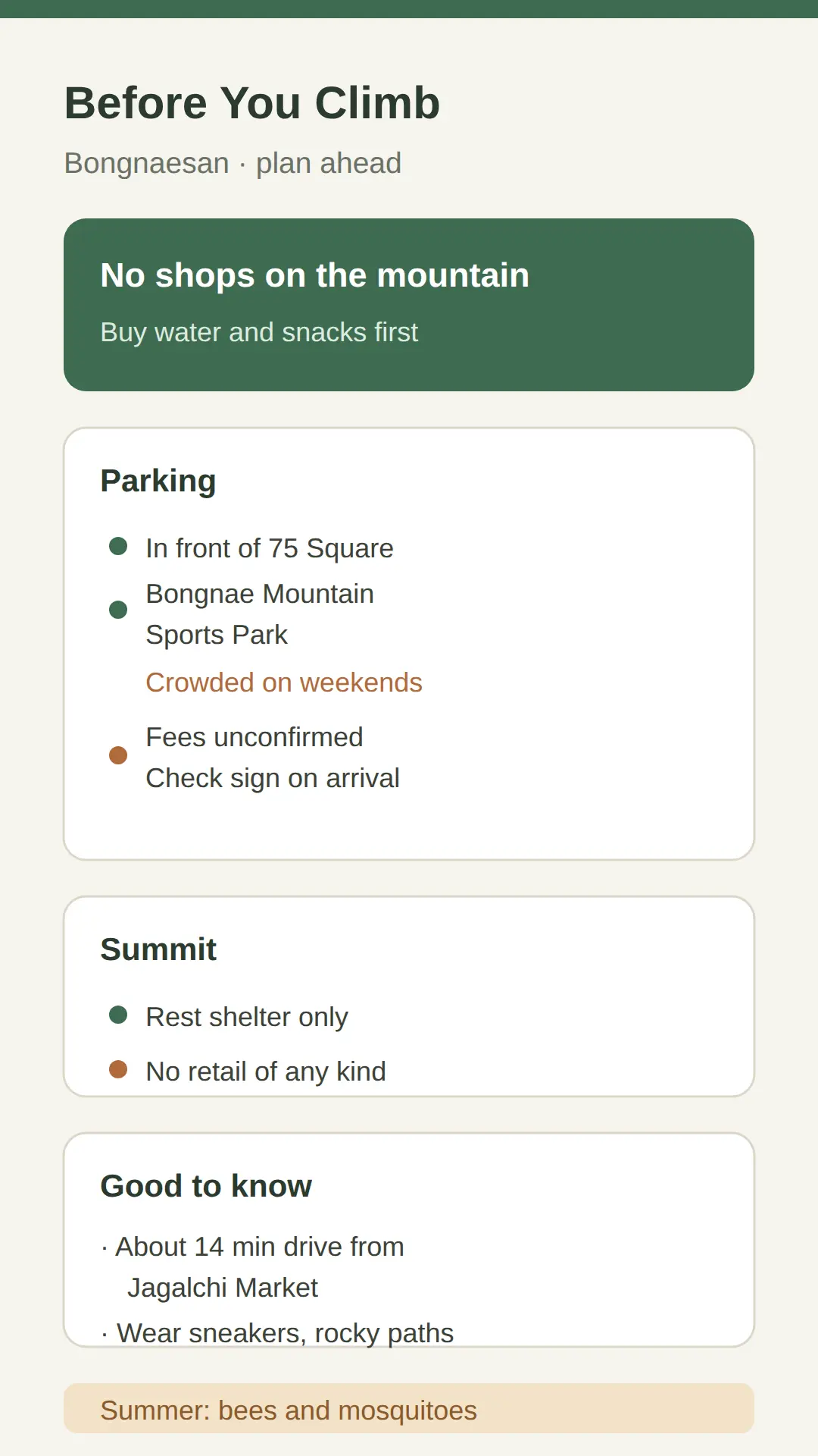
Buy water and snacks before you start — there are no shops or stands inside the mountain.
The city guide lists a public parking lot in front of 75 Square, and the mountain is about a 14-minute drive from Jagalchi Market.
A second lot is reported near Bongnae Mountain Sports Park, but it is crowded on weekends; no parking fee for either lot could be confirmed in the sources, so check the posted sign on arrival.
The summit has a rest shelter but no retail of any kind, so convenience stores near Yeongdo-gu Office or the Namhang area are the last stop for supplies.
Wear sneakers — paths mix rocky and dirt sections — and in summer expect bees and mosquitoes.
Sunset, Night View And The Lamppost Question
Arrive 30–40 minutes before sunset and use the west-facing middle platform — the sunset sky is best from there.
Viewpoints face both east and west, so the mountain works for sunrise and sunset, and the night view of the Namhang Bridge lights is a highlight.
Lampposts are confirmed only on the Sinseon-dong boardwalk route, which has three viewing platforms and a large summit platform with benches and glass railings.
No dated source confirms lighting on the Mokjangwon Course after dark, so if you are out late, the boardwalk is the safe pick — on a night hike it is the route that keeps the walk back lit.
Spring and autumn are the recommended seasons; on a clear horizon Tsushima (Japan) is visible from the summit.
What To Eat Nearby And How It Fits A Busan Day
| What to check | Detail |
|---|---|
| Where to eat in Yeongdo-gu | City-guide list of places to eat (koreankorea.com) |
| Coming from Seoul | Check the KTX Seoul–Busan timetable (koreankorea.com); Nampo-dong side is about a 20-minute drive from Busan Station |
| On the descent | Huinnyeoul Culture Village (mural alleys, sea-view cafés), Jeolyeong Coastal Trail, National Maritime Museum nearby |
| Timing | 1-hour ascent plus the sunset slot against your KTX arrival time |
For food after the hike, start from the city’s list of places to eat in Yeongdo-gu (koreankorea.com).
On the descent, Huinnyeoul Culture Village offers mural alleys and sea-view cafés, the Jeolyeong Coastal Trail adds a cliff-top walk, and the National Maritime Museum is nearby.
If you are coming from Seoul for a same-day hike, check the KTX Seoul–Busan timetable (koreankorea.com) to build the day; the Nampo-dong side is about a 20-minute drive from Busan Station.
One mountain, one village, one meal covers a half-day easily — if the summit is cloudy, shift the summit time and keep the coastal walk.
For a same-day visitor, the practical check is the KTX arrival time against a 1-hour ascent plus the sunset slot.
I would take the boardwalk route and arrive 30–40 minutes before sunset — the west-facing mid-mountain platform is where the sunset colors read best, and the night view of the Namhang Bridge lights is the payoff for staying late.
👉 Busan Metropolitan City English guide (visitbusan.net)
👉 Bongnaesan hike guide (hiking-beginner.com)
👉 Jeolyeong Coast Loop (hiking-beginner.com)
👉 Bongnaesan short hike with great views (britadventures.com)
Related posts
📎 📅 Upcoming Dates — Release & Event Calendar
Sources
- Dulle-gil ranked among Korea’s top five coastal trails; cypr (world.nol.com)
- visitbusan.net themed trip ‘Nighttime Trekking in Bongnaesan (visitbusan.net)
- Nampo Station exit 6 + buses (source list varies), Sweet Pot (britadventures.com)
Quick Summary
- Bus 508, 7 or 71 from the Yeongdodaegyo Bridge & Nampo Station stop; get off at 75 Square, then walk 5 minutes.
- Open all year, no closed days, no entry fee — per the visitbusan.net city guide (October 4, 2026).
- Shortest way up and down: Huinnyeoul Village Course, 3.5 km, ~1 hr 30 min.
- Evening hike: Sinseon-dong boardwalk — the only route with confirmed lampposts.
- No shops on the mountain — buy water and snacks in advance at convenience stores around Yeongdo-gu Office or Namhang.
FAQ
Q. How do I get to Bongnaesan Mountain in Busan?
Metro Line 1 to Nampo Station exit 6, then bus 508, 7 or 71 to the 75 Square stop and a 5-minute walk, per the official visitbusan.net entry. Re-check bus numbers at the stop — other sites list different routes.
Q. Is Bongnaesan Mountain open all year and what does it cost?
Yes — hours are listed as "Always" (open all year, no closed days) and the hiking trails are free, per the city guide checked October 4, 2026.
Q. Are there lampposts on Bongnaesan for a night hike?
Lampposts are confirmed only on the Sinseon-dong boardwalk route (2.7 km out-and-back). No dated source confirms lighting on the Mokjangwon Course after dark.
Q. Which Bongnaesan course is the easiest?
The Huinnyeoul Village Course — 3.5 km, about 1 hour 30 minutes, the shortest of the maintained courses.
Q. Where can I eat in Yeongdo-gu after the hike?
Use the city’s list of places to eat in Yeongdo-gu, and check the KTX Seoul–Busan timetable first if you are building a same-day trip from Seoul.
The city guide’s themed trip "Say goodbye to heat! Nighttime Trekking in Bongnaesan Mountain" (published October 4, 2026, by travel writer Mun Cheol-jin) is the reference plan: dusk start, summit in about an hour, sunset and night view. The cypress forest on the mountain is designated as a forest-bathing area.
Cover photo: 이상규원장(AMJ) by 칼빈500 — CC BY-SA 3.0
#Busan #Yeongdo #BongnaesanMountain #hiking #Busandaytrip #Koreatravel
📅Upcoming Schedule — this week 2 · D-2 Hangul DaySee all →