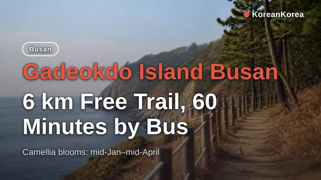
From Hadan Station (Busan Metro Line 1) Exit 3, take Bus 58 to Seonchang Bus Stop — about 60 minutes — for a 6 km coastal trail that is free and open all year round.
That means a car-free visitor can do the island in a normal Busan day: one metro ride, one bus, then walking.
This post covers the transit route, driving and the Geoga Bridge toll, hours and fees, how long the walks take, what to see, and what the new airport changes in 2026.
Key facts — As of 2026-10-02
- The Gadeokdo Coastal Trail is a 6 km free walking route open all year round, reached by Bus 58 from Hadan Station (Busan Metro Line 1), per the Busan city English guide (visitbusan.net, 2026-10-03).
- Gadeokdo Lighthouse, first lit in 1909 and Busan Tangible Cultural Property No. 50, sits inside a Navy protection zone and requires advance approval via the Gangseo-gu Office (051-970-4062).
- Galmaetgil Course 5 Section 2 runs 20.1 km and takes about 6-8 hours, while the Yeondaebong (459.4 m) round trip takes 2-3 hours.
Getting to Gadeokdo Island by Metro and Bus
| No car, coming from central Busan | Metro Line 1 to Hadan Station Exit 3, then Bus 58 or 58-2; allow about 60 minutes on the bus |
|---|---|
| Want the lighthouse | Call the Gangseo-gu Office at 051-970-4062 in advance — walk-ins are not allowed |
| Short on time | Yeondaebong round trip (2–3 hours) or walk only to the lighthouse, not the full 20.1 km section |
| Planning around the new airport | Stick to the north and east of the island; check Daehang village access before going |
| Coming from Seoul | KTX to Busan Station (about 2.5–3 hours), then Metro Line 1 to Hadan |
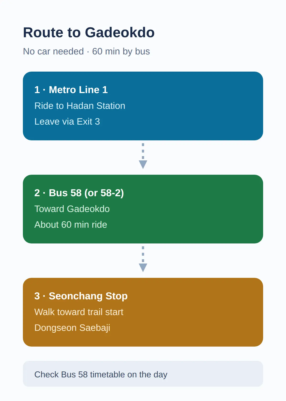
- Ride Busan Metro Line 1 to Hadan Station and go out Exit 3.
- Take Bus 58 (or 58-2) toward Gadeokdo and get off at Seonchang Bus Stop — the ride takes about 60 minutes.
- From the stop, walk toward Dongseon Saebaji and you reach the coastal trail.
The city’s English guide lists this as the route: Hadan Station Exit 3, Bus 58, Seonchang Bus Stop, then the trail toward Dongseon Saebaji (visitbusan.net, October 3, 2026).
The trail runs from Dongseon Saebaji to Daehang Saebaji along rock formations with the South Sea beside you.
If you are coming from Seoul, take the KTX to Busan Station first — about 2.5–3 hours — then Metro Line 1 to Hadan, because Busan Station is the closest KTX stop to the island.
Before anything else, I check how you actually reach the island without a car and whether the place you want needs advance approval, because parts of Gadeokdo are still Navy zones.
The first and last departures of Bus 58 are not confirmed from an official source, so verify the timetable on the day you go.
Getting there — Gadeokdo Island
- Seoul → Busan by train: fastest 2h 18m, from ₩46,700, 109 trains a day, first 05:13 · last 22:40 · timetable
- Seoul → Busan by express bus: fastest 4h 00m, from ₩29,100, 35 buses a day, first 06:00 · last 24:00 · timetable
- Last leg: about 28.9 km from Busan Station — roughly 34 min by taxi or car without traffic; local buses also run (check the stop sign or a map app)
- Map: Naver Map · Kakao Map · Google Maps
Calculated by koreankorea.com from the national train and express-bus timetables, OpenStreetMap road distance. Plan your own route
Gadeokdo by Car — Bridges, Driving Time and the Geoga Bridge Toll
By car, Gadeokdo is about 40–50 minutes from central Busan via Gadeok Bridge and Nulcha Bridge, and the Nulcha Bridge opened in 2009 to link the island by road for the first time.
The Geoga Bridge, opened in December 2010, connects the island to Geoje about 8 km away through a 4,066 m cable-stayed bridge section and an 18-span immersed tunnel.
Car tolls on the Busan–Geoje Fixed Link are reported at KRW 3,400 one-way as of 2026, with a HiPass discount of roughly 10 percent (about KRW 3,060) — these figures come from secondary sources, and the operator’s official toll page could not be opened directly.
So compare it like this: the city bus from Hadan costs a regular fare and takes about 60 minutes, while driving costs the toll and takes 40–50 minutes from central Busan.
If you already rent a car for other Busan sights, driving is the faster choice; without one, the Bus 58 route is confirmed and costs nothing extra.
Hours and Fees — What Is Free and What Needs Permission
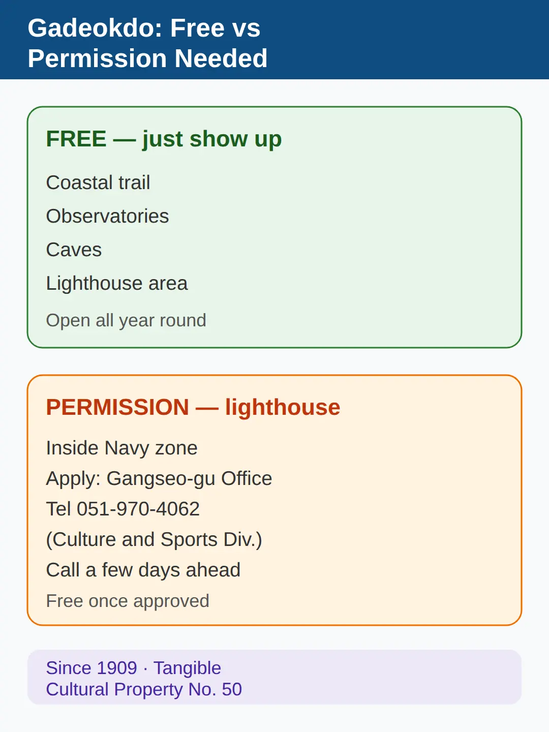
The coastal trail, observatories, caves and lighthouse area are free, and the city guide lists the trail as open all year round.
The one exception is the lighthouse itself: it sits inside a Navy protection zone, so you need advance approval through the Gangseo-gu Office (051-970-4062, Culture and Sports Division) before you can visit — and it is free once approved.
Gadeokdo Lighthouse, first lit in 1909 during the Korean Empire era and Busan Tangible Cultural Property No.
50, requires that advance approval via the Gangseo-gu Office (visitbusan.net, 2026).
Do not assume you can walk up to it — the approval process and how long it takes are not confirmed, so I would only add the lighthouse to the day if I got approval by phone a few days ahead.
Everything else on this list you can simply show up for.
How Long It Takes — Full Trail vs Short Options
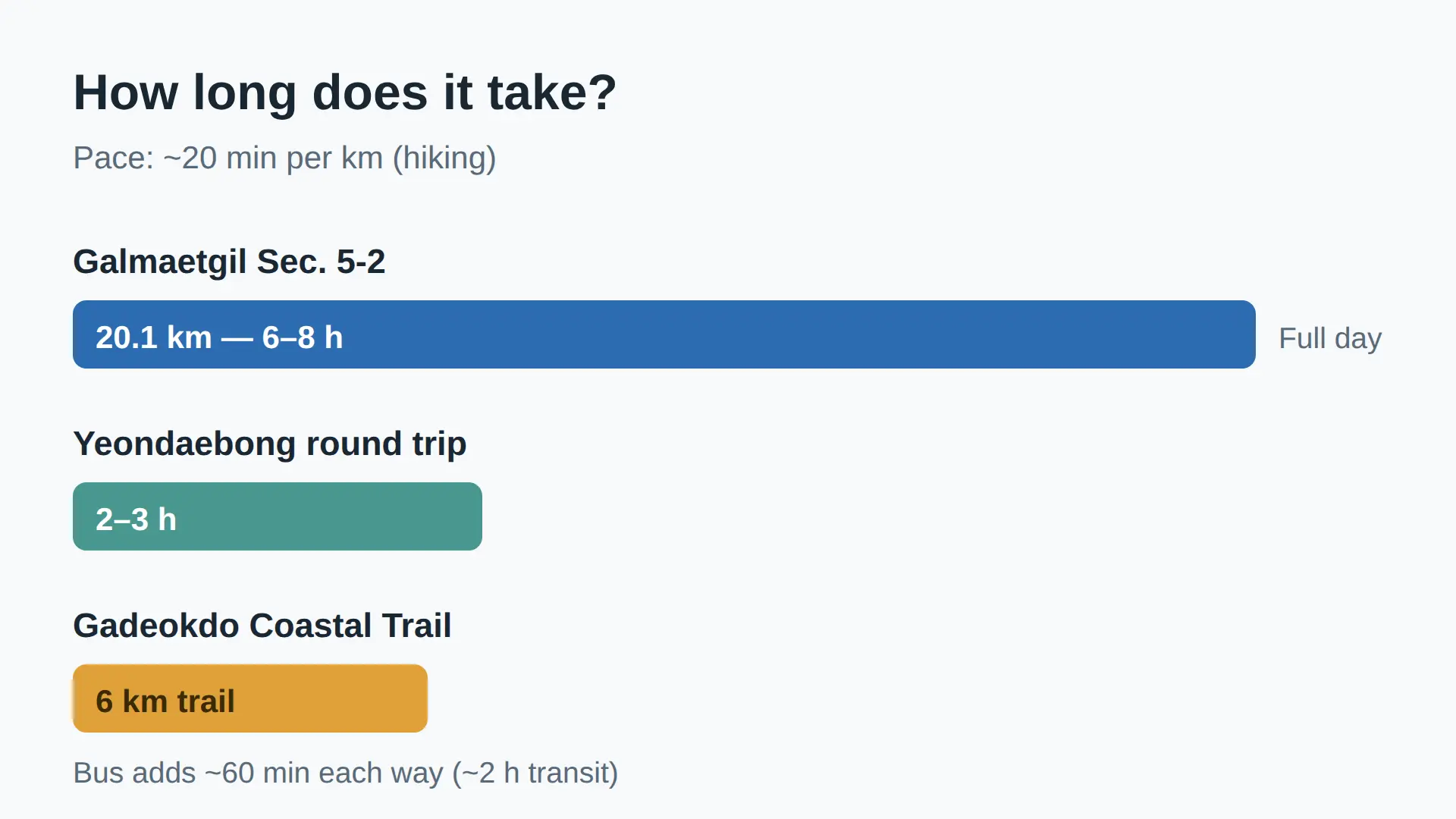
The Gadeokdo Coastal Trail is 6 km, while the full Galmaetgil Course 5 Section 2 across the island is 20.1 km and takes about 6–8 hours, so the two are not the same walk.
Galmaetgil Course 5 Section 2 runs 20.1 km from Cheongagyo via Yeondaebong (459.4 m), Daehang Port and Saebaji Port, while the Yeondaebong round trip alone takes 2–3 hours.
A rough check: 20.1 km in 6–8 hours works out to about 20 minutes per km, which is hiking pace on a coastal section.
On top of that, the bus ride each way adds about 60 minutes, so a full trail day costs roughly 2 hours of transit plus walking time.
Budget-minded readers should pick the row that matches their day, not the longest number on the list.
What to See Along the Way — Camellias, Caves, Mural Village, Observatory
Along the 6 km trail you pass Nureungneung Pass (a residential area until the 1970s, now an observatory) on the way to Eoeumpo Port, with sea cliffs over 100 m high on the southeast coast.
The camellia grove on the southeastern cliff — Busan Monument No.
36, about 2,500 trees over 150 years old — blooms from mid-January to mid-April, so that is the window if flowers are the point.
The Daehang fortress caves, about 10 artificial caves built with forced Korean labor during the Pacific War, are free and open year-round at Gadeokdo Haean-ro 21 (same phone, 051-970-4062), with interior lighting and a walk through to a pebble beach.
Jeongeo Mural Village, an old anchorage village now filled with murals in narrow alleys, is reached by a different bus: Hadan Station, then Bus 520, get off at Dongjung Village stop.
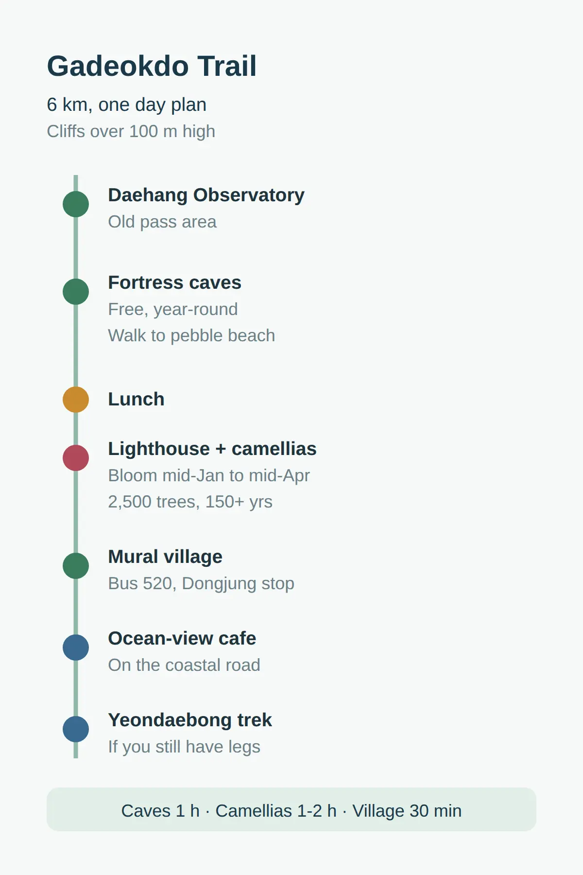
A workable day course: Daehang Observatory, the caves (about 1 hour), lunch, lighthouse and camellia grove (1–2 hours), the mural village (about 30 minutes), then an ocean-view cafe — plus the Yeondaebong trek if you still have legs.
For food, the city’s restaurant listing for Gangseo-gu (the district that contains Gadeokdo) is the place to check before you go; Daehang also offers a fishing village experience with pull-net fishing, boat fishing, mussel picking and boat rowing.
Ocean-view cafes sit on the coastal road, and access to the Daehang village area itself should be checked before you go, because relocation there is ongoing.
The New Airport Caveat — What Is Still Visitable in 2026
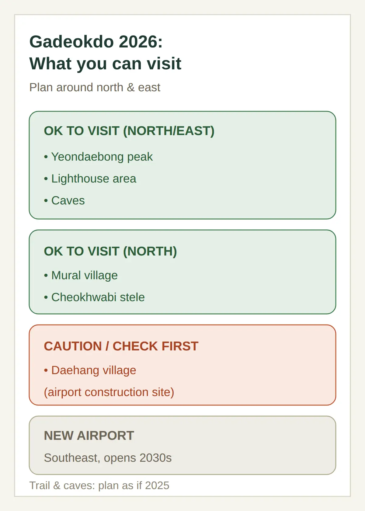
As of 2026, the main sights — Yeondaebong, the lighthouse area, the caves and the mural village — are normally visitable; the island’s south around Daehang village is the airport construction site, where resident relocation is in progress.
The southeastern part of the island is the confirmed site for the Southeastern Region New Airport, with a target opening in the 2030s, while most tourist sights cluster in the north and east and are largely unaffected.
The Busan New Port container terminal already occupies the northern part of the island in Seongbuk-dong, where the Cheokhwabi stele (Busan Monument No.
- also stands.
So the practical rule is simple: build the day around the north and east, and check access to Daehang village before heading south.
If your visit is only about the trail and the caves, the airport changes nothing for now — plan the day as if it were 2025.
Related posts
📎 📅 Upcoming Dates — Release & Event Calendar
Sources
- Monument designations, 2002 lighthouse, camellia bloom windo (ko.wikipedia.org)
- 2026 accessibility status, day course, Goudinerv cafe, reloc (blog.ne.kr)
- Geoga Bridge opened 2010, ~30 min from city center, Yeondaeb (informaticsview.com)
A One-Day Gadeokdo Plan
- Metro Line 1 to Hadan, Exit 3, then Bus 58 to Seonchang — about 60 minutes each way.
- Walk the 6 km coastal trail from Dongseon Saebaji toward Daehang Saebaji, passing Nureungneung Observatory and Eoeumpo Port.
- Call 051-970-4062 a few days ahead only if the lighthouse is the point of your trip.
- Time the visit between mid-January and mid-April if you want the 150-year-old camellias in bloom.
- Figures in this post are as of October 3, 2026.
FAQ
Q. How do I get to Gadeokdo Island in Busan?
From Hadan Station (Busan Metro Line 1) Exit 3, take Bus 58 or 58-2 to Seonchang Bus Stop — about 60 minutes — then walk toward Dongseon Saebaji on the coastal trail. By car it is about 40–50 minutes from central Busan via Gadeok and Nulcha bridges.
Q. Is the Gadeokdo Coastal Trail free?
Yes — the city guide lists the trail as free and open all year round, and the observatories and caves are free as well. Only the lighthouse needs advance approval, and it is free once approved.
Q. Can I visit the Gadeokdo Lighthouse without permission?
No. The lighthouse is inside a Navy protection zone, so you need advance approval through the Gangseo-gu Office at 051-970-4062 before visiting. How long the approval takes is not confirmed, so call a few days ahead.
Q. How long does the Gadeokdo Coastal Trail take?
The 6 km coastal trail is the day-walk option, while the full Galmaetgil Course 5 Section 2 is 20.1 km and takes about 6–8 hours. The Yeondaebong round trip alone is 2–3 hours.
For the rest of a Busan day, the city’s Gangseo-gu restaurant listing and the KTX Seoul–Busan timetable are linked in the text above.
Cover photo: AI-generated illustration (coastal cliff trail) — AI-generated image, illustrative only
#GadeokdoIsland #Busandaytrip #Busancoastaltrail #Busanwithoutacar #GeogaBridge #Gangseo-gu
📅Upcoming Schedule — this week 2 · D-2 Hangul DaySee all →