The Jeju Olle Trail is 425 km over 26 routes — 21 regular routes and 5 sub-routes — and walking one route per day takes about a month.
Each route is sized for one day: roughly 13–21 km and 4–7 hours, so you pick routes instead of committing to the whole trail.
This post gives the confirmed distances and hours route by route, then shows which route fits one day, a few days, or a full walk of the trail.
Key facts — As of 2026-10-09
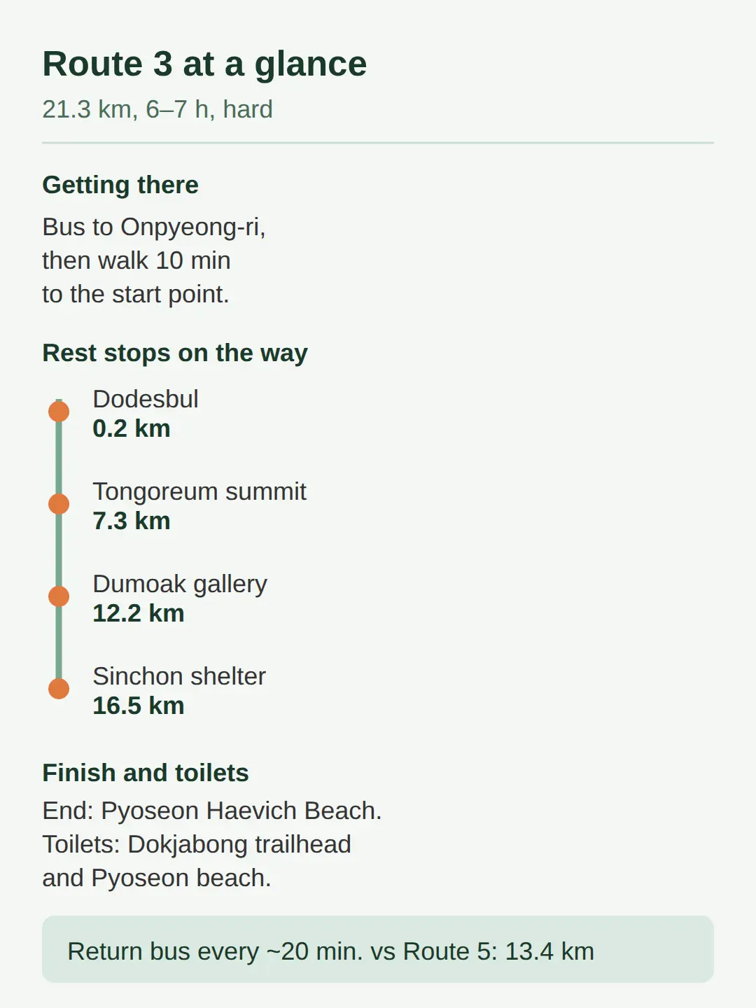
- Per the gathered route data, Route 3 is the longest confirmed route at 21.3 km and 6-7 hours, rated hard, running Onpyeong Port → Pyoseon Haevich Beach.
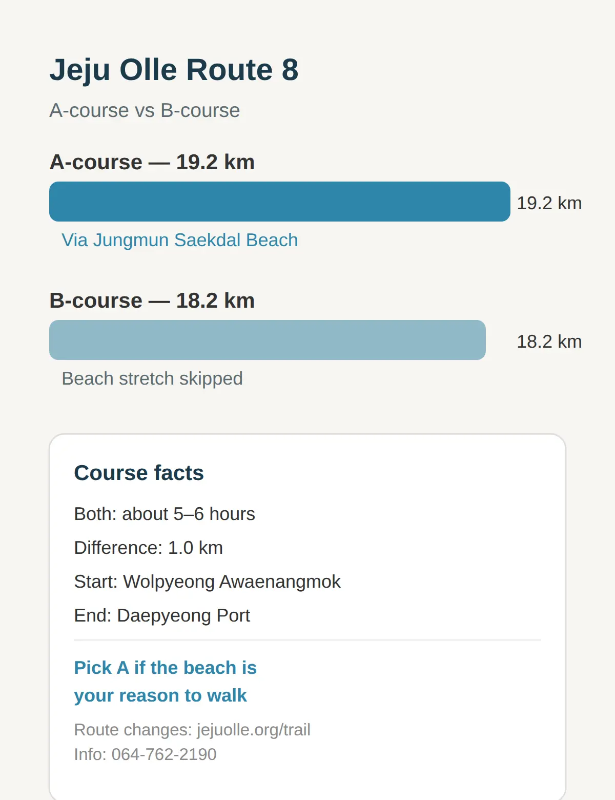
- Per the gathered route data, Route 8 splits into an A-course of 19.2 km (via Jungmun Saekdal Beach) and a B-course of 18.2 km, both about 5-6 hours.
- Per the best-season data, October-November is the ideal walking window at 18-23°C with the year’s lowest rainfall.
Jeju Olle Trail Route Map: 26 Routes and 425 km, One Route Per Day
The Jeju Olle Trail is 425 km over 26 routes — 21 regular routes and 5 sub-routes — divided into 425 ÷ 26 = about 16.3 km per route on average.
That average is the size of a normal walking day, which is why the trail is planned route by route rather than as one continuous trek.
| Route | Length | Time | Notes |
|---|---|---|---|
| 1 | 15.1 km | 4–5 hours | — |
| 2 | 15.6 km | ~4 hours | Gwangchigi Beach → Onpyeong Port via Seongsan area |
| 3 | 21.3 km | 6–7 hours | Rated hard; Onpyeong Port → Pyoseon Haevichi Beach |
| 5 | 13.4 km | 4–5 hours | Shortest confirmed route |
| 7 | 17.6 km | 5–6 hours | — |
| 8 | 19.2 km (A) / 18.2 km (B) | 5–6 hours | A-course via Jungmun Saekdal Beach |
| 18 | 19.7 km | 6–7 hours | — |
| 20 | 17.6 km | 5–6 hours | — |
Routes 4, 6, 9–17, 19 and 21 and the 5 sub-routes are not verified here, and jejuolle.org route pages list them all.
Note that only Routes 2, 3, 5 and 8 are labeled coastal vs inland in the sources — do not assume the others from the map alone.
If you want the whole trail, plan about a month of one-route-per-day walking; otherwise pick single routes that fit your days on the island.
Before anything else I check jejuolle.org for route changes, because routes are sometimes detoured or changed and a map read last month may be out of date.
How Long Does Each Jeju Olle Route Take?
Confirmed routes take 4–7 hours each, and the full trail takes about 30 days at one route per day.
Route 1 is 15.1 km in 4–5 hours, Route 2 is 15.6 km in about 4 hours for a mid-level hiker, and Route 7 is 17.6 km in 5–6 hours.
Route 3 is the longest confirmed route at 21.3 km and 6–7 hours, rated hard, running Onpyeong Port → Pyoseon Haevich Beach.
Route 8 splits into an A-course of 19.2 km (via Jungmun Saekdal Beach) and a B-course of 18.2 km, both about 5–6 hours.
Route 18 at 19.7 km and Route 20 at 17.6 km both take 6–7 and 5–6 hours respectively, sitting near that 16.3 km average.
Plan your day on the longest number in the range — a 6–7 hour route is a full daylight walk with breaks.
Which Jeju Olle Route Should I Walk First?
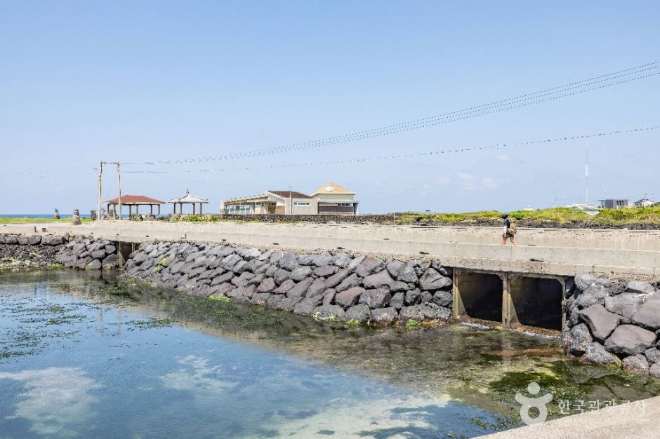
With one day, walk the Route 5 highlight section Namwon Port → Umi Port, and with more days move to Route 2, Route 3 or Route 8.
Jeju Olle itself recommends walking only the highlight section of each route when your trip is short, and VisitJeju features 5 must-walk routes for exactly that purpose.
Route 5’s highlight section is the shortest confirmed route’s coastal stretch, it includes the ‘Geuneung’ scenic point, and the signature experience is the unmanned honesty-box cafes where walkers rest and pay on trust.
If I had one day, that is the section I would pick — it is coastal, moderate, and the honesty-box cafes make the break stops part of the walk.
For a full route with a coastal feel, Route 2 (15.6 km, ~4 hours) follows the blue coastline from Gwangchigi Beach to Onpyeong Port.
Fit hikers wanting the longest confirmed route get Route 3, and walkers who want varied scenery and sights get Route 8 — the choice depends on how many hours you can give.
Route 3: How to Get There, Where to Eat, Where the Toilets Are
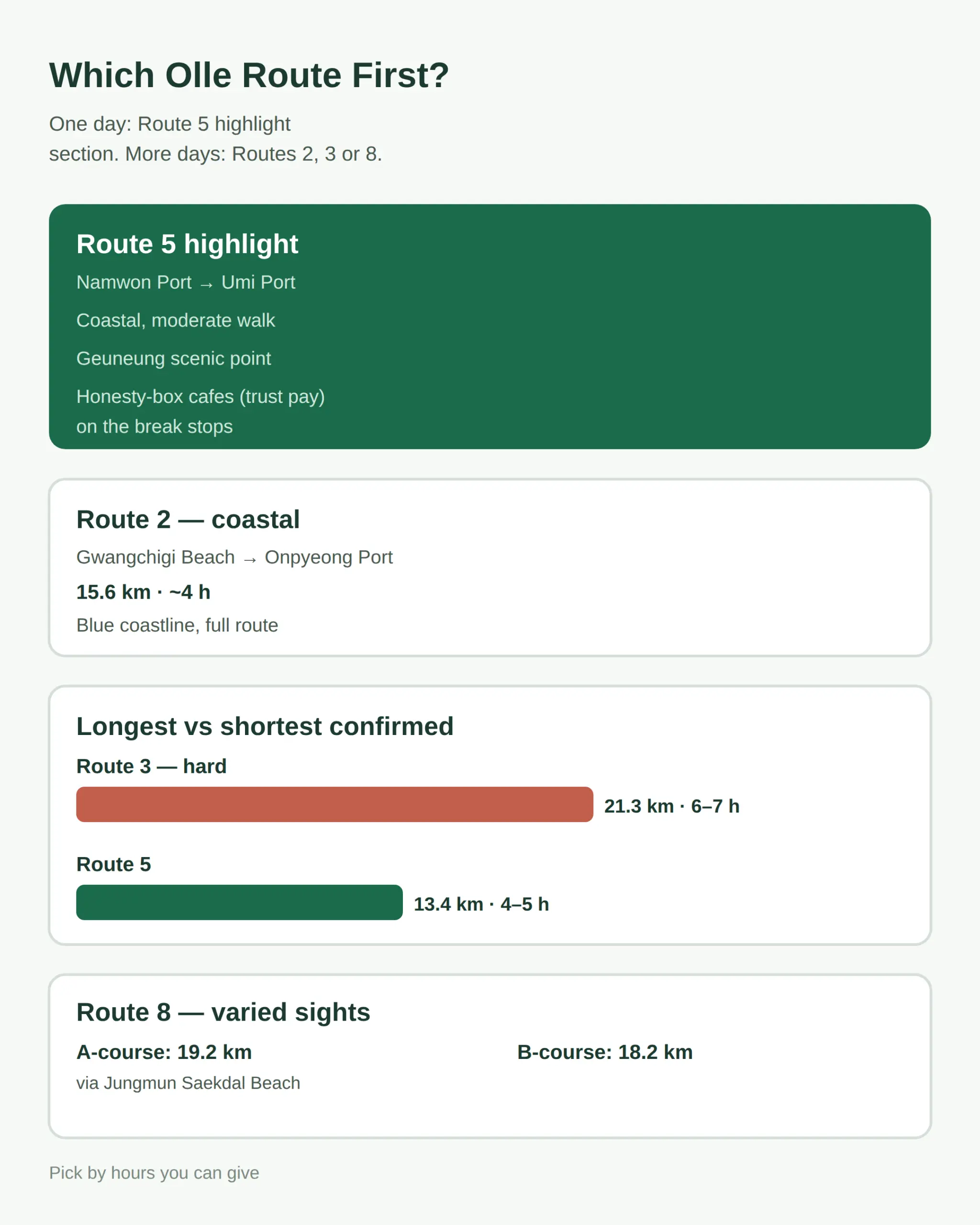
Route 3 starts with an intercity bus from Jeju to Seogwipo on the east coast line via Seongsan; get off at Onpyeong-ri and walk about 10 minutes to the Onpyeong Comprehensive Information Center where the route starts.
- Take the Jeju–Seogwipo intercity bus (east coast line via Seongsan) and get off at Onpyeong-ri.
- Walk about 10 minutes to the Onpyeong Comprehensive Information Center (the start point).
- On Route 3, rest stops are at Dodesbul (0.2 km), Tongoreum summit (7.3 km), Kim Young-gap Gallery Dumoak (12.2 km) and the Sinchon haenyeo dressing shelter (16.5 km).
- Toilets sit near the Dokjabong entrance and near Pyoseon Haevich Beach at the end.
- Finish at Pyoseon Haevich Beach and catch the return bus to Jeju City from the Jeju Folk Village Museum parking lot stop.
The return bus runs about every 20 minutes, so the way back does not need advance planning.
Jeju Olle Passport holders get 20% off admission at Jeju Folk Village Museum, which sits right on Route 3, so bring the passport if you are collecting stamps.
Bus intervals are long on rural Olle endpoints — check timetables in advance rather than assuming a bus will be waiting.
Hexagonal rock columns, four-colored sand and a freshwater swim in 19.2 km
Route 8 packs the most sights into one walk: Jusangjeolli hexagonal rock columns, Yakcheonsa’s three-story temple, a view of Mara and Gapado islands from Beritnae Oreum, four-colored sand at Saekdal Beach, and the calm Nonjitmul swimming spot.
The route runs from Wolpyeong Awaenangmok Shelter to Daepyeong Port, with the A-course (19.2 km) adding Jungmun Saekdal Beach and the B-course (18.2 km) leaving it out — both take about 5–6 hours.
The A-course is 1.0 km longer, and since both take the same 5–6 hours, the A-course is the better pick when the beach stretch is the reason you are walking.
From the Beritnae Oreum summit, Mara Island and Gapado are visible on clear days.
Near Nonjitmul, the Gaealkkatdaegi area on the Yeolli Coastal Trail is a designated firefly protection zone, so keep noise and light down there.
For questions about Route 8, the official contact is 064-762-2190, and route changes are posted at jejuolle.org/trail#/road/08.
Stamps, Passport and Checking Before You Go
Jeju Olle runs 9 official route info centers where you get route maps and buy the stamp passport, and you collect a stamp at each route end.
- Buy the stamp passport at one of the 9 official info centers.
- Collect a stamp at the end of each route you finish.
- Show the passport at Jeju Folk Village Museum for 20% off admission.
- Check jejuolle.org before every walk for detours or route changes.
October and November are the ideal walking window: 18–23°C with the lowest rainfall of the year, so if your dates are flexible, aim for those months.
In winter, Sinchon Ranch on Route 3 dries tangerine peels in orange waves across the fields — a different reward for the same 21.3 km.
Which route is prettiest and beginner-friendly is the question walkers ask most, and the answer follows the same rule: start with a highlight section (Route 5’s coastal stretch) before committing to a full hard-rated route like Route 3.
Related posts
📎 📅 Upcoming Dates — Release & Event Calendar
Sources
- Route 5 highlight: Namwon Port to Umi Port; Pyoseon/Namwon c (visitjeju.net)
- Route 2: 15.6 km, ~4 h; varied terrain; Jeju-dong Mart is th (chunbun2025.tistory.com)
- Route 3: 21.3 km, 6-7 h, hard; waypoints, toilets, access bu (clips6.tistory.com)
Plan In Three Steps
- Before every walk, check jejuolle.org for detours and route changes — what the map showed last month may already be out of date.
- On Route 2, carry enough food and water past Jejudong Mart, the last reliable store before the finish.
- With one day on the island, walk the Route 5 highlight section Namwon Port → Umi Port — coastal, moderate, with unmanned honesty-box cafes along the way.
- Buy the stamp passport at one of the 9 official route info centers, and use it for 20% off admission to Jeju Folk Village Museum on Route 3.
FAQ
Q. How many routes does the Jeju Olle Trail have and how long is it in total?
26 routes — 21 regular routes and 5 sub-routes — over 425 km combined. One route per day takes about a month to walk the whole trail.
Q. Which Jeju Olle route should I walk first?
With one day, the Route 5 highlight section Namwon Port → Umi Port is the easiest pick: it is coastal, moderate, and includes the Geuneung scenic point and the unmanned honesty-box cafes. Jeju Olle itself recommends highlight sections for short trips.
Q. How long does each Jeju Olle route take?
Confirmed routes take 4–7 hours: Route 1 (15.1 km, 4–5 h), Route 2 (15.6 km, ~4 h), Route 3 (21.3 km, 6–7 h, hard), Route 5 (13.4 km, 4–5 h), Route 7 (17.6 km, 5–6 h), Route 8 A/B (19.2/18.2 km, 5–6 h), Route 18 (19.7 km, 6–7 h), Route 20 (17.6 km, 5–6 h).
Q. Does the Olle Passport cost anything and how long is it valid?
A stamp passport exists and is sold at the 9 official Jeju Olle info centers, but the 2026 purchase price and validity period are not confirmed here. Ask at an info center or check jejuolle.org before you go.
Q. When is the best time to walk the Jeju Olle Trail?
October–November: 18–23°C and the lowest rainfall of the year. In winter, Route 3’s Sinchon Ranch dries tangerine peels in orange waves across the fields, which is a different reason to walk then.
Not sure how many days you have? Pick one highlight section per day — Jeju Olle’s own recommendation for short trips — and buy the stamp passport at the first info center you pass.
Cover photo: Jeju Olle Trail Route 20 (올레 20코스) by Korea Tourism Organization — KOGL Type 1 (attribution)
#jejuolletrail #jejuolleroutemap #jejuhiking #jejuitinerary #koreatravel
📅Upcoming Schedule — this week 3 · D-1 documentary 'Always Lalisa' global theatrical release (Oct 1See all →Last updated 2026-10-10. Editorial policy